Ik verwerk uav data in point cloud, orthomosaic, dtm, dsm, 3d modellen en contour

A
aashish_baral
A
aashish_baral
Aashish
Sommige informatie is automatisch vertaald.

Over deze dienst

Automatische vertaling

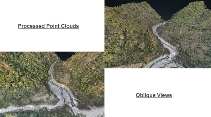
Ben je op zoek naar professionele UAV photogrammetrie verwerking (van beelden tot LiDAR data) voor jouw GIS, landmeetkunde of kaartproject? Ik kan je helpen om je ruwe UAV-data om te zetten in nauwkeurige geospatiale producten die klaar zijn voor analyse en kaartvorming.


Ik ben gespecialiseerd in drone photogrammetrie verwerking en LiDAR point cloud classificatie om hoogwaardige terrein- en kaartuitvoer te produceren voor ingenieurs, landmeters, planners en GIS-professionals.

Diensten die ik aanbied:

  • Drone beeldverwerking en orthomosaic generatie
  • LiDAR point cloud classificatie (grond, gebouwen, vegetatie)
  • Digital Elevation Model (DEM) creatie
  • Digital Surface Model (DSM) generatie
  • Contourkaart generatie
  • 3D terreinmodellering


Leveringen omvatten:

GeoTIFF orthomosaics, LAS/LAZ geclassificeerde point clouds, 3D textuurmodellen voor visualisatie en meting, DEM/DSM hoogte modellen, contour shapefiles en GIS-compatibele formaten.

Ik gebruik professionele tools zoals PIX4DMapper, DJI Terra, DJI Modify, Global Mapper, ArcGIS Pro en QGIS om nauwkeurige resultaten te garanderen.

  • Neem contact met mij op voordat je bestelt, zodat we je dataset en projectvereisten kunnen bespreken.

Maak kennis met Aashish

Aashish

GIS Analyst, Spatial Analysis, Mapping, Remote Sensing, LiDAR, Photogrammetry

  • Afkomstig uitNepal
  • Lid sindsnov 2025
  • Gem. reactietijd1 uur
  • Talen

    Nepalees, Engels, Hindi
Geomatics Engineer skilled in GIS, remote sensing, LiDAR Data Processing, Photogrammetry and spatial analysis. Proficient in ArcGIS, QGIS, Global Mapper, LiDAR Softwares, PIX4DMapper & Google Earth Engine. I offer GIS, Remote Sensing, Photogrammetry, LiDAR and other geospatial services using industry standard softwares. If you need clean spatial datasets, decision‑ready maps, or automated geoprocessing workflows, I can design and deliver a solution tailored to your project.

Automatische vertaling