a
adriangaray622

Adrian G

@adriangaray622
5,0(1)
Argentinië
Spaans
Sommige informatie wordt in het Engels weergegeven.
Over mij
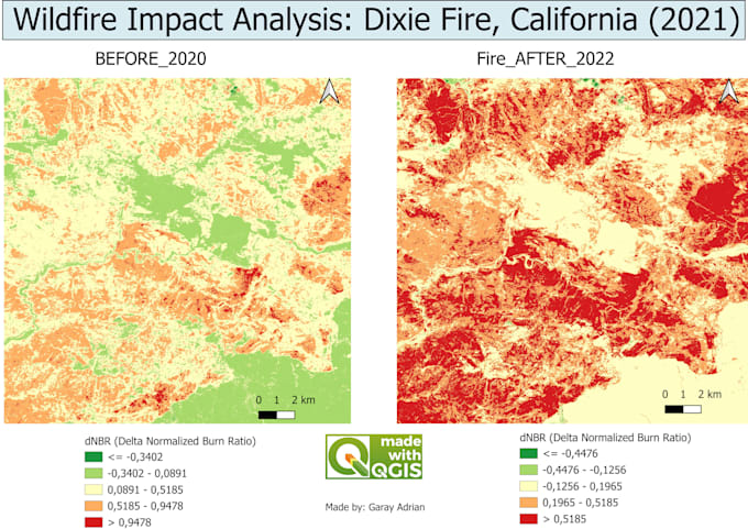
Hello! I am a University Technician in Geographic Information Systems (GIS) and Remote Sensing. I have experience in managing and analyzing spatial data using tools such as QGIS, ArcGIS and specialized remote sensing software such as ENVI and Google Earth Engine. My training allows me to transform complex geospatial data into valuable information for decision-making in projects related to the environment, territorial planning, precision agriculture, and much more. What can I offer you? Geospatial data analysis (GIS) Processing and analysis of satellite images. Creation of custom thematic map... Lees meer

Skills

a
adriangaray622
Adrian G
offline • 
Gemiddelde reactietijd: 1 uur

Bekijk mijn diensten

Geografisch informatiesysteem (GIS)
I will do satellite analysis for change detection and wildfires

Portfolio

1 Reviews
5,0

(1)
(0)
(0)
(0)
(0)
Specificering van de beoordeling
  • Communicatieniveau van de freelancer
    5
  • Kwaliteit van de levering
    5
  • Waarde van de levering
    5
1-1 van 1 reviews
Sorteer op
Meest relevant
    R
    image-docs

    romanzw

    ZW

    Zimbabwe

    5

    very happy with my delivery and will definitely order again.

    Tot maximaal US$ 50

    Prijs

    4 dagen

    Looptijd

    Nuttig?
    Ja
    Nee