Door categorieën bladeren
Ontdekken
Fiverr Pro
Nederlands
$
USD


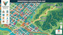
LOST USERS, CONFUSED VISITORS & CLUTTERED MAPS? TURN EVERY LOCATION INTO A CLEAR JOURNEY WITH BOLD MAPBOX MAPPING
A confusing map drives customers away, wastes time, and creates costly navigation mistakes.
Whether you need Mapbox Maps, Vector Maps, Density Maps, Route Planning, Hiking Trails, Downtown Maps, Google Website Maps, or interactive navigation, I craft location experiences that help people reach the right destination faster.
Solution Arsenal:
Why Clients Return:
Project Assets:
Message me before ordering and let's transform complex locations into intuitive, professional maps that improve navigation, strengthen your brand, and deliver a better user experience.
Laat het de freelancer weten als je voorkeuren voor of zorgen hebt over het gebruik van AI-tools voor het voltooien en/of leveren van je bestelling.
Cartographer and map designer
Talen
Can you simplify complex geographic information for non-technical users?
Definitely. I organize dense geographic data into clean, intuitive maps that improve decision-making, reduce navigation errors, and enhance the overall user experience.
Will my map remain scalable without losing quality?
Yes. Vector-based mapping ensures your map stays sharp for websites, mobile applications, presentations, signage, and large-format printing without pixelation.
Can you optimize maps for tourism, parks, resorts, or downtown navigation?
Yes. I build destination-focused maps that highlight landmarks, trails, attractions, routes, parking, visitor facilities, and points of interest for a seamless navigation experience.
Can you transform raw GPS, GIS, or spreadsheet data into an interactive Mapbox map?
Yes. I can convert GPX, KML, GeoJSON, Shapefiles, CSV, and coordinate datasets into organized, interactive Mapbox maps with custom layers, styling, and navigation-ready outputs.
Can you match my company's branding instead of using standard Mapbox styles?
Absolutely. Every project can be tailored with your brand colors, typography, icons, layer hierarchy, and visual identity, creating a map that feels like part of your business rather than a generic template.


