Door categorieën bladeren
Ontdekken
Fiverr Pro
Nederlands
$
USD


Automatische vertaling
Live Demo:
https://wayanad-landslide-emergency-response.duckdns.org
Een krachtig en modern WebGIS-toepassing bouwen voor rampenbeheer, milieumonitoring, infrastructuurplanning, noodhulp, ruimtelijke analyse en interactieve mapping.
Ik ben gespecialiseerd in het ontwikkelen van aangepaste GIS-webapplicaties met GeoServer, OpenLayers, QGIS, PostGIS, HTML, CSS, JavaScript en AWS deployment. Ik kan jouw GIS-gegevens omzetten in een interactieve ruimtelijke dashboard met professionele UI/UX en real-time kaartinteractie.
De diensten omvatten:
Interactieve WebGIS Dashboards
GeoServer installatie & configuratie
OpenLayers Web Mapping
WMS/WFS integratie
API integratie
ETL, automatiseringspipeline
Visualisatie van ruimtelijke analyse
Kaart van rampen & noodgevallen
Routing & toegankelijkheid mapping
Aangepaste GIS-laagstyling (SLD)
AWS deployment & SSL setup
PostGIS integratie
Ondersteunde formaten:
Shapefile, GeoJSON, GeoPackage, Raster TIFF, PostGIS, WMS/WFS services en meer.
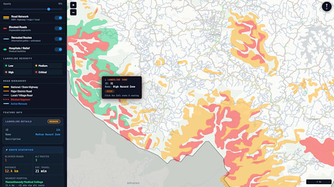
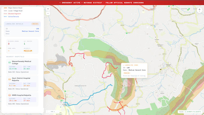
Onlangs ontwikkelde ik een compleet Landslide Emergency Response WebGIS platform met landslide ernst mapping, hospital toegankelijkheidsanalyse, geblokkeerde wegdetectie, herrouteringsvisualisatie en interactieve besluitvormingshulpmiddelen.
GIS analyst and specialist
Talen
Automatische vertaling
Automatische vertaling
Wat voor soort WebGIS-toepassingen kun je bouwen?
Ik kan rampenbeheersingsdashboards, milieumonitoringsystemen, platformen voor noodgevallen, infrastructuurmappingportals, routeringsystemen, ruimtelijke analyse dashboards en op maat gemaakte interactieve GIS webapplicaties bouwen.
Welke technologieën gebruik je?
Ik gebruik vooral GeoServer, OpenLayers, QGIS, PostGIS, HTML, CSS, JavaScript, AWS EC2, Nginx en SLD styling voor GIS webontwikkeling.
Kun je de WebGIS-toepassing online plaatsen?
Ja. Ik kan je project op AWS of je favoriete cloudserver plaatsen met SSL/HTTPS-configuratie en domeininstelling.
Welke GIS-dataformaten ondersteun je?
Ik ondersteun Shapefiles, GeoJSON, GeoPackage, Raster TIFFs, CSV-spatial data, PostGIS-databases, WMS/WFS-services en vele andere GIS-formaten.
Werkt de applicatie op mobiele apparaten?
Ja. Ik kan responsieve WebGIS dashboards maken die compatibel zijn met desktop, tablet en mobiele apparaten.