Door categorieën bladeren
Ontdekken
Fiverr Pro
Nederlands
$
USD


Automatische vertaling
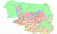
Ik digitaliseer professioneel jouw kaarten, tekeningen of satellietbeelden naar nauwkeurige GIS-dataformaten zoals Shapefiles, GeoJSON of KML. Met behulp van industry-standard software zoals ArcGIS en QGIS zorg ik voor precieze vectorisatie, juiste georeferentie en schone attribute tabellen. Of je nu gescande kaarten, CAD-bestanden of veldschetsen wilt omzetten in bruikbare GIS-lagen, ik lever datasets van hoge kwaliteit die direct klaar zijn voor gebruik.
Deze service is ideaal voor stedelijke planning, milieustudies, rampenbeheer, landgebruik mapping en academische projecten. Met mijn expertise als Geomatics Engineer garandeer ik nauwkeurige ruimtelijke data die voldoen aan professionele normen. Je kunt rekenen op tijdige levering, duidelijke communicatie en resultaten die aansluiten bij jouw specifieke wensen.
GIS Remote Sensing Google Earth Engine Python
Talen
Automatische vertaling
