Ik maak kaart en ruimtelijke analyse in arcmap arcgis pro qgis

A
awais_sajid1940
A
awais_sajid1940
Awais Sajid
Sommige informatie is automatisch vertaald.

Over deze dienst

Automatische vertaling

Wil je je data omzetten in bruikbare inzichten?

Ik ben een GIS-expert met 2 jaar ervaring in ruimtelijke data-analyse, kaart maken en geografische oplossingen. Ik blink uit in het omzetten van complexe datasets in duidelijke, informatieve kaarten en rapporten.

Ik heb praktische ervaring met werken in ArcGIS, Google Maps, Google Earth Pro, Google Earth Engine, QGIS & Erdas Imagine.

Ruimtelijke analyse, GIS-kaart maken, WebGIS, ArcGIS, QGIS, Python

Diensten die ik aanbied:

  • Geoprocessing
  • Geospatiale en geostatistische analyse
  • Verkrijging en creatie van geospatiale data
  • Ruimtelijke analyse & modellering
  • Overlay & weighted overlay analyse
  • Hotspot & coldspot analyse
  • Topologie en netwerk analyse
  • Verwerking en acquisitie van remote sensing data
  • Navigatiesystemen
  • Landgebruik / landbedekking analyse
  • Multi-criteria besluitvorming
  • Locatiegeschiktheidsbeoordeling
  • Beeldclassificatie (onbegeleid, begeleid, objectgebaseerd etc.)
  • Cartografische kaarten

GIS, GIS-kaart maken, kaarten

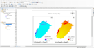
De output kan een cartografische kaart, shapefiles, geodatabase of CSV-bestanden zijn.

Ik overleg met jou om het optimale dataformaat (kaarten, shapefiles, geodatabases, CSV) en analysemethode te bepalen, zodat het perfect aansluit bij jouw projectdoelen.

NEEM VOORAF CONTACT MET ME OP VOORDAT JE HIRING

Maak kennis met Awais Sajid

Awais Sajid

GIS and Remote Sensing Consultant

  • Afkomstig uitPakistan
  • Lid sindsaug 2022
  • Talen

    Urdu, Engels
I have an experience of 1+ years in Geographical Information system (GIS) and Remote Sensing (RS). I'm a professional Geospatial data analyst. I also can do Remote Sensing tasks. Google Maps, Google Earth Pro expert. I have experienced the Geospatial Data Acquisition and Creation, Cartographic Maps, Land Use & Zoning Maps, Geoprocessing, Image Processing etc. I can work on ArcGIS, QGIS, Erdas Imagine softwares. Feel free to contact me prior to place an order to discuss specific details about project and data.

Automatische vertaling