Door categorieën bladeren
Ontdekken
Fiverr Pro
Nederlands
$
USD

Automatische vertaling
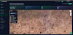
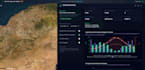
Ik ontwikkel een professionele interactieve WebGIS-toepassing met React, OpenLayers/MapLibre en PostgreSQL/PostGIS, dezelfde stack als achter BioAtlasDZ en institutionele kust-GIS portals (GIZ, CNL).
Wat je krijgt:
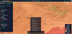
Responsieve webkaart met WMS/WFS-lagen, pop-ups, filters en legenden
Geospatiale zoekfunctie, teken-/meetgereedschappen en export (PNG/PDF/GeoJSON)
Schoon React/TypeScript frontend + API backend
PostGIS database ontwerp en data-import (Shapefile, GeoJSON, CSV)
Optionele GeoServer publicatie en VPS-implementatie
Ideaal voor: milieudashboards, perceeltracking, biodiversiteitsatlassen, verzekeringsgeoportalen, gemeentelijke GIS-portalen.
Live referenties: bioatlasdz.com · app.geochainlabs.com
Stack: React 19 · TypeScript · OpenLayers · FastAPI/Node.js · PostGIS · GeoServer · Nginx
Stuur me je datavorm, gebruiksgeval en tijdlijn. Ik reageer snel met een duidelijk leveringsplan.
Let erop dat het tegen het beleid van Fiverr voor freelancers is om thema's, templates of andere elementen in het geleverde werk op te nemen die inbreuk maken op de rechten van derden of toepasselijke wetten. Lees er meer over in onze Gids voor verantwoorde digitale creatie.
Geomatician and full stack developper
Talen
Automatische vertaling
Automatische vertaling
Lever je de geospatiale data aan?
Ja. Ik kan je Shapefile, GeoJSON, KML of PostGIS dump structureren en importeren. Als je data verzameling nodig hebt, vraag dan een aangepaste offerte aan.
Kun je satellietbeelden integreren?
Ja — Sentinel, Google Earth Engine of WMS tile services kunnen in de kaart worden geïntegreerd.
Bieden jullie ondersteuning na de bevalling?
Ja. 30 dagen bug-fix ondersteuning inbegrepen bij Premium; uitgebreide onderhoudsmogelijkheden beschikbaar.


