Door categorieën bladeren
Ontdekken
Fiverr Pro
Nederlands
$
USD
Geospatial Analist Drone, DEM en 3D Terrain Modeling
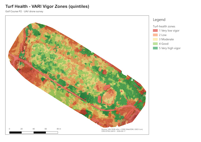
Heb je dronebeelden op je harde schijf staan waar niemand iets mee heeft gedaan? Ik analyseer ze en maak een kleurgecodeerde kaart van de vegetatiegezondheid die precies laat zien waar je gewassen, gazon of vegetatie gestrest, bloeiend of slecht is, zone voor zone.
WAT JE STUURT:
RGB dronebeelden (VARI werkt met elke drone, inclusief DJI Air/Mavic/Phantom)
Multispectrale beelden (NDVI Micasense, DJI Multispectral, Parrot Sequoia)
GeoTIFF orthofoto of map met ruwe beelden
Kleurgecodeerde kaart van vegetatievigor (5 zones: uitstekend tot gestrest)
Printklare kaart op 300dpi (PNG + PDF)
Georeferentie GeoTIFF output
Samenvatting van zone-statistieken
QGIS projectbestand
VARI werkt met standaard RGB-camera's, multispectrale sensor is niet nodig. Als je een DJI Mavic, Air of Phantom hebt, werken je beelden al.
Gebruikt door: golfbaanmanagers, boeren, landbouwadviseurs, turfbeheerbedrijven, milieukundigen, landbeheerders.
Geaccepteerde formaten: GeoTIFF, orthofoto, JPG-map, ruwe dronebeelden
Doorlooptijd: standaard 24 uur