Door categorieën bladeren
Ontdekken
Fiverr Pro
Nederlands
$
USD

Level 2
Geomatics Engineer ! Photogrammetry Expert
Skills
Bekijk mijn diensten

Wil je op uurbasis werken?
Vertel Saifullah Khan wat je nodig hebt.
US$ 15
/
uurAssistant Manager Geomatics Engineer
Zameen.com • Fulltime
Jan 2021 - Feb 2022 • 1 yr 1 mo
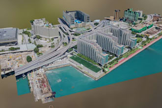
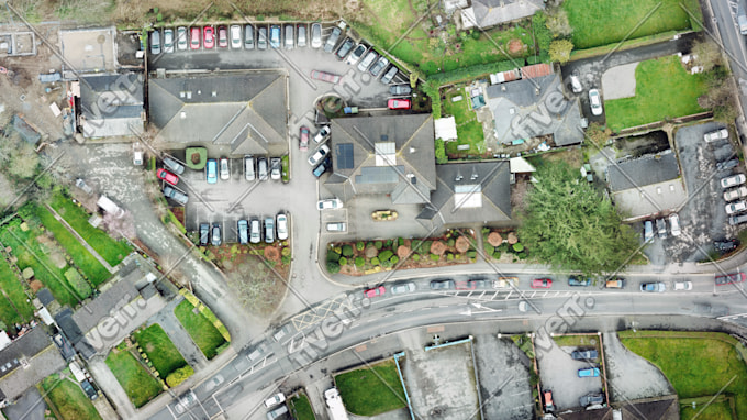
Drone Based Photogrammetry Models and Imagery Managing and handling drone team for generating high resolution 2D imagery and photorealistic 3D model of the true ground. Creating interactive 3D model for developer, investors and stakeholders, where they can interact with 3D model and get the details of construction progress and monitor accordingly. Defining objectives, roles and assigning the responsibilities to the team members. Planning and implementing the strategy to cover the project area and generate the required deliverables. https://www.zameengeomatics.com/public/zameen-aurum/ PlotFinder Spatial Data Handling Generated automated and semi-automated postgreSQL/SQL scripts and functions for processing of spatial data. Data quality and accuracy are being ensured using the scripts. Database policies for the teams for data creation and data QAQC. Processing the raster and vector tiling for the website. https://www.zameen.com/plotfinder/
Associate Geomatics Engineer
zameen.com (EMPG Labs) • Fulltime
Nov 2018 - Jan 2021 • 2 yrs 2 mos
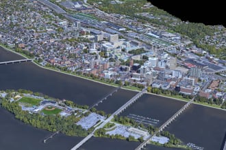
Supervised drone operations for aerial data acquisition and processing, delivering high-accuracy 2D orthomosaics, photorealistic digital twins, 3D mesh models, and dense point clouds of project sites. Led survey planning and execution to ensure complete and reliable data capture, and implemented Mapbox-based mapping services to support efficient drone image acquisition workflows. Following data processing, optimized 2D web tiles for orthomosaics and 3D mesh models were generated to enable fast and effective web-based visualization of geospatial data.
GIS Analyst
TPLMaps • Fulltime
Feb 2018 - Nov 2018 • 9 mos
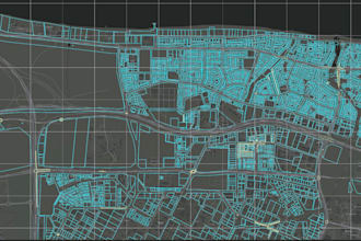
I contributed to the creation and digitization of spatial data for TPL Maps across multiple large-scale projects, ensuring high positional accuracy of spatial features. The datasets were systematically stored and managed within a PostgreSQL/PostGIS database. I also developed semi-automated Python and SQL scripts to cross-verify feature accuracy and integrity, significantly enhancing overall data quality and reliability.
| (145) | ||
| (3) | ||
| (0) | ||
| (0) | ||
| (0) |
mandladlamin740
Terugkerende klant

Zuid-Afrika
Excellent work, good turn around time and clear communication. Much appreciated.

mkabk96
Terugkerende klant

Ierland
very happy and will be working with him again
mkabk96
Terugkerende klant
Ierland
Very happy and would recommend highly
davidekika
Terugkerende klant

Verenigd Koninkrijk
curiousorion
Verenigd Koninkrijk
Fantastic work, will absolutely work with him again if I need a similar project.