Door categorieën bladeren
Ontdekken
Fiverr Pro
Nederlands
$
USD

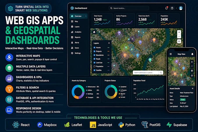
Need a professional Web GIS application, interactive map or geospatial dashboard for your business or project?
I build modern, responsive mapping applications that turn spatial data into interactive and easy-to-use web experiences.
I can build:
Technologies: React, JavaScript, Mapbox, Leaflet, Python, PostGIS, Supabase, GeoJSON, ArcGIS and geospatial APIs.
Whether you need a simple interactive map or a complete GIS dashboard, I can develop a solution tailored to your workflow and data.
Please message me before ordering for database integration, APIs or advanced custom applications.
Let erop dat het tegen het beleid van Fiverr voor freelancers is om thema's, templates of andere elementen in het geleverde werk op te nemen die inbreuk maken op de rechten van derden of toepasselijke wetten. Lees er meer over in onze Gids voor verantwoorde digitale creatie.
GIS Developer
Talen
1. What type of Web GIS applications can you build?
I can build interactive web maps, GIS dashboards, asset and parcel viewers, location intelligence platforms, data portals, monitoring dashboards and custom geospatial web applications.
2. Which mapping technologies do you work with?
I can work with technologies such as React, Mapbox, Leaflet, JavaScript, GeoJSON, Python, PostGIS, Supabase and geospatial APIs depending on your project requirements.
3. Can you connect my Web GIS app to a database or API?
Yes. I can integrate spatial databases, APIs and other data sources where required. Please contact me before ordering because the cost depends on the complexity of the integration.
4. Can you add charts, filters, search and KPI cards to the dashboard?
Yes. I can add interactive charts, statistics, filters, search tools, layer controls, legends, popups, KPI cards and other dashboard functionality.
5. Can you work with my existing GIS data?
Yes. I can work with common geospatial formats such as GeoJSON, Shapefile, GeoPackage, KML/KMZ, CSV with coordinates and raster data. I can also discuss database-based datasets.