Door categorieën bladeren
Ontdekken
Fiverr Pro
Nederlands
$
USD


Automatische vertaling
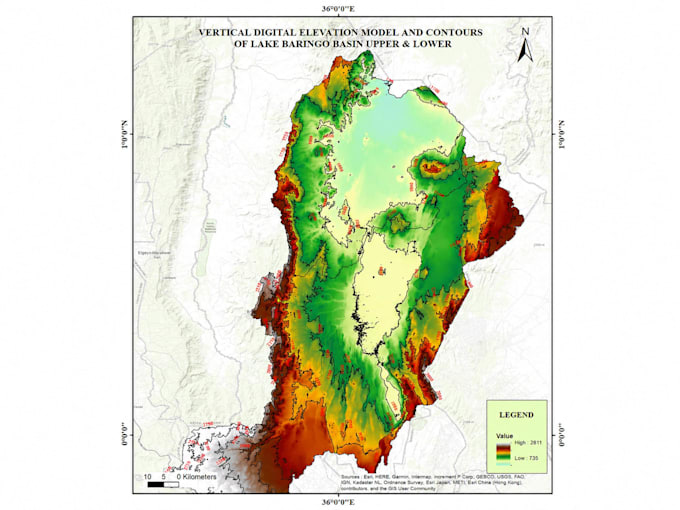
Ben je op zoek naar professionele GIS-mapping, ruimtelijke analyse of maatwerk kaarten? Je bent op de juiste plek!
Ik ben een GIS & Remote Sensing specialist met meer dan 5 jaar ervaring in het leveren van hoogwaardige geospatiale oplossingen voor milieuprojecten, infrastructuur, nutsvoorzieningen, natuurbehoud en ontwikkeling in Kenia en daarbuiten.
Wat ik aanbied:
Tools die ik gebruik: QGIS, ArcGIS, ArcPro, Google Earth Engine, ILWIS, Python (geospatiale automatisering)
GIS Expert, Remote Sensing Specialist, Data Analyst, AI ML Specialist, Drone Pil
Talen
Automatische vertaling
Automatische vertaling
Welke informatie moet ik verstrekken om aan de slag te gaan?
Deel je interessegebied (coördinaten, shapefile of beschrijving), het type kaart/analyse dat je nodig hebt, je voorkeur voor software (QGIS/ArcGIS), en eventuele data die je al hebt. Ik begeleid je vanaf daar!
Welke bestandsformaten ontvang ik voor de eindproducten?
Je ontvangt je kaarten als hoge resolutie PNG/PDF voor print of presentatie, plus shapefiles (.shp), GeoJSON of geodatabaseformaten voor GIS-data, afhankelijk van jouw wensen.
Kun je werken met mijn bestaande data of satellietbeelden?
Ja! Ik kan werken met jouw shapefiles, rasterdata, GPS-punten, CSV-coördinaten of satellietbeelden. Ik haal ook data uit Google Earth Engine, OpenStreetMap en andere platforms indien nodig.
Hoe lang duurt een typisch GIS-mapping project?
Eenvoudige kaarten duren 1-2 dagen. Ruimtelijke analyse of projecten met meerdere lagen duren 3-5 dagen. Complexe geodatabase- of remote sensing-werkzaamheden kunnen langer duren. Tijden worden altijd vooraf besproken.
Bied je revisies aan als ik niet tevreden ben met het resultaat?
Absoluut! Ik bied revisies aan om te zorgen dat de uiteindelijke kaart aan jouw verwachtingen voldoet. Duidelijke communicatie en klanttevredenheid staan bij mij voorop.