Door categorieën bladeren
Nederlands
$
USD
Koppel je AI aan Fiverr

Automatische vertaling
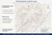
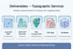
Contourlijnen + hoogtelijnen
AutoCAD DWG-bestanden
QGIS-project + SHP Shapefile
ArcGIS-compatibel
KML voor Google Earth
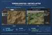
PDF van hoge kwaliteit + 3D-terrainmodel
WAAROM IK?
Precisie op centimeterniveau
Snelle levering
Onbeperkte revisies tot jouw tevredenheid
Ondersteuning na levering
Ideaal voor: bouw, woongebied, wegenbouw, landbouw, bouwvergunning.
Laat het de freelancer weten als je voorkeuren voor of zorgen hebt over het gebruik van AI-tools voor het voltooien en/of leveren van je bestelling.
Topographe SIG ExpertAutocad covadis
Talen
Automatische vertaling
Automatische vertaling
Welke bestanden ontvang ik?
Dwg Autocad + SHP ArcGIS + PDF
Werk je zonder GPS-gegevens?
Ja, ik kan vanaf Google Earth maken
Snelle levering?
Ja, 24-uurs optie beschikbaar tegen een extra kosten van 15$


