Door categorieën bladeren
Ontdekken
Fiverr Pro
Nederlands
$
USD

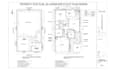

Need a site plan, plot plan, or landscape drawing for a permit but unsure if your plan meets city or zoning requirements? Many projects get delayed or rejected due to missing details, incorrect scaling, unclear layouts, or non-compliance, causing repeated revisions, wasted time, and extra costs. I solve this by creating accurate 2D CAD site plans designed for permit submission, clearly showing property boundaries, structures, and layouts. Ideal for homeowners, contractors, builders, and developers who need reliable drawings to move projects forward with confidence.
SERVICE I OFFER:
WHAT YOU WILL GET
Message me before ordering so we can discuss your project and ensure the best permit ready site plan.
Laat het de freelancer weten als je voorkeuren voor of zorgen hebt over het gebruik van AI-tools voor het voltooien en/of leveren van je bestelling.
Site Plans, Floor Plans And 3D Designs You Can Trust
Talen
Should I contact you before placing an order?
Yes, it is strongly recommended. This ensures I fully understand your project requirements and helps avoid delays or revisions later.
What do you need from me to start?
To begin, I only need your property details such as address, sketch, survey, PDF, or even a Google Maps location. If you are unsure, I can guide you on what works best for your project before starting.
Can your site plan be used for city permit approval?
Yes. I create permit-ready site plans designed to clearly show property boundaries, structures, setbacks, and layout details commonly required for city or zoning submission. However, final approval depends on your local authority requirements.
What if my previous plan was rejected?
No problem. Many clients come after rejection. I can review your existing drawing, identify missing or incorrect details, and recreate it in a proper scaled CAD format that meets submission standards.
Can you work with rough sketches or Google Maps only?
Yes. I can convert sketches, PDFs, or Google Maps into accurate scaled CAD drawings. If information is limited, I will guide you on what is needed to ensure accuracy.
Do you offer revisions if changes are needed?
Yes. Revisions are included based on your selected package to ensure your drawing matches your requirements and project expectations.
How accurate are your drawings?
I focus on precise scaling, clear property boundaries, and proper layout structure. I use available data such as sketches, surveys, or satellite references to ensure high accuracy for planning and submission use.
What file formats will I receive?
You will receive high-quality PDF for printing and DWG/DXF files for editing and technical use, depending on your package.
How fast can you deliver?
Delivery time depends on project size, but I always aim for fast turnaround while maintaining accuracy. If you need urgent delivery, you can request it before placing the order.
Can you handle complex or large properties?
Yes. I handle both simple residential lots and large-scale developments including subdivisions, multi-structure layouts, and commercial site plans.


