Door categorieën bladeren
Ontdekken
Fiverr Pro
Nederlands
$
USD


Automatische vertaling
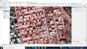
Ik doe digitalisering van geplande gebieden, ongeplande gebieden met attributen. Ik maak een speciaal model of attributen, die aan al jouw categorieën voldoen.
Geplande gebieden
Ongeplande gebieden
ontwikkelde gebieden
Onontwikkelde gebieden
Attributen
Ik maak andere kaarten:
1. Thematische kaart en lay-out voorbereiding
2. Data conversie (naar Raster, KML, Shapefile, Geodatabase en Raster)
3. Data projectie en transformatie
4. Digitale hoogtemodel
5. Georeferentie
6. Landgebruik en landbedekking
7. Watershed-afbakening
8. Stroom- of afwateringsdichtheid
9. Studiegebied kaart
10. Rivierstroom-orde kaart
11. NDVI en andere indices
12. Landoppervlaktetemperatuur
13. Hotspot misdaadanalyse
Talen
Automatische vertaling


