Het lijkt erop dat deze dienst tijdelijk niet beschikbaar is

I will do geospatial analysis using arcgis pro

G
gyanadapanda
G
gyanadapanda
Gyanada Panda
Sommige informatie wordt in het Engels weergegeven.

Over deze dienst

This Gig includes the following tasks under various packages:

  1. Geo referencing any raster/map/toposheets etc
  2. Clip, Erase, Intersect, Spatial Join etc,
  3. Buffer analysis, Contour mapping
  4. Density Mapping : Point Mapping, Heat Map [Eg : Population density, Crime Mapping, Tree density, Hot spot analysis]
  5. Landuse/ landcover classification
  6. Hydrology
  7. Weighted overlay
  8. Segmentation and classifiacation
  9. Surface Analysis


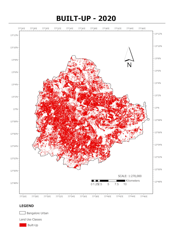
I can also do remote sensing, spatial analysis and modeling etc.

  • Network analysis
  • Land cover analysis
  • Watershed delineation
  • Flood mapping
  • Forest monitoring
  • Site suitability assessment
  • Drainage analysis
  • Multi-criteria analysis and much more


***I can also do your complex GIS projects and assignments

Output can be cartographic map or shapefiles or geodatabase or CSV files.

I will help you decide the required data type and type of analysis that could serve your purpose.

Kindly contact me before placing your order

Maak kennis met Gyanada Panda

Gyanada Panda
  • Afkomstig uitIndia
  • Lid sindsjun 2020
  • Talen

    Engels, Hindi
Hello I am a Remote Sensing and GIS enthusiast and currently working as a senior project scientist in Indian Institute of Technology Delhi. I have research experience in flood and meteorological studies, extreme events and their impact on urban areas. I also specialize in the field of geospatial implications of urban and regional studies. My skillsets includes ArcGIS, QGIS, ERDAS Imagine, Python, R, SQL, Adobe InDesign, Adobe Illustrator, AutoCAD etc. Looking forward to working with you all.