Door categorieën bladeren
Ontdekken
Fiverr Pro
Nederlands
$
USD

_oeeq5t.jpg)
Automatische vertaling
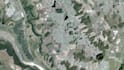
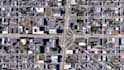
Ik bied high-resolution satellietbeelden downloads die klaar zijn voor gebruik in GIS-software.
Perfect voor mapping, visualisatie, planning en rapporten.
Bronnen kunnen Google, Bing of andere openbare beeldplatforms zijn (alleen voor visualisatie en mapping doeleinden).
Smart Solutions in GIS, Excel Automation, and Web Development
Talen
Automatische vertaling
Automatische vertaling
Is dit beeldmateriaal geschikt voor GIS-software?
Ja. Alle bestanden zijn geo-referentie en GIS-klaar
Kun je een specifiek coördinatensysteem matchen?
Ja, vermeld het gewoon in het verzoek


