Door categorieën bladeren
Ontdekken
Fiverr Pro
Nederlands
$
USD
Level 1
CivilEngineer,Geotechnical Specialist, Groundwater Modeller, Estimator
Skills
Bekijk mijn diensten
RESEARCH ASSOCIATE/FIELD ENGINEER
NATIONAL INSITUTE OF URBAN INFRASTRUCTURE AND PLANNING UNIVERSITY OF ENGINEERING AND TECHNOLOGY PESHAWAR • Fulltime
Dec 2024 - Present • 1 yr 7 mos
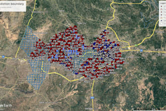
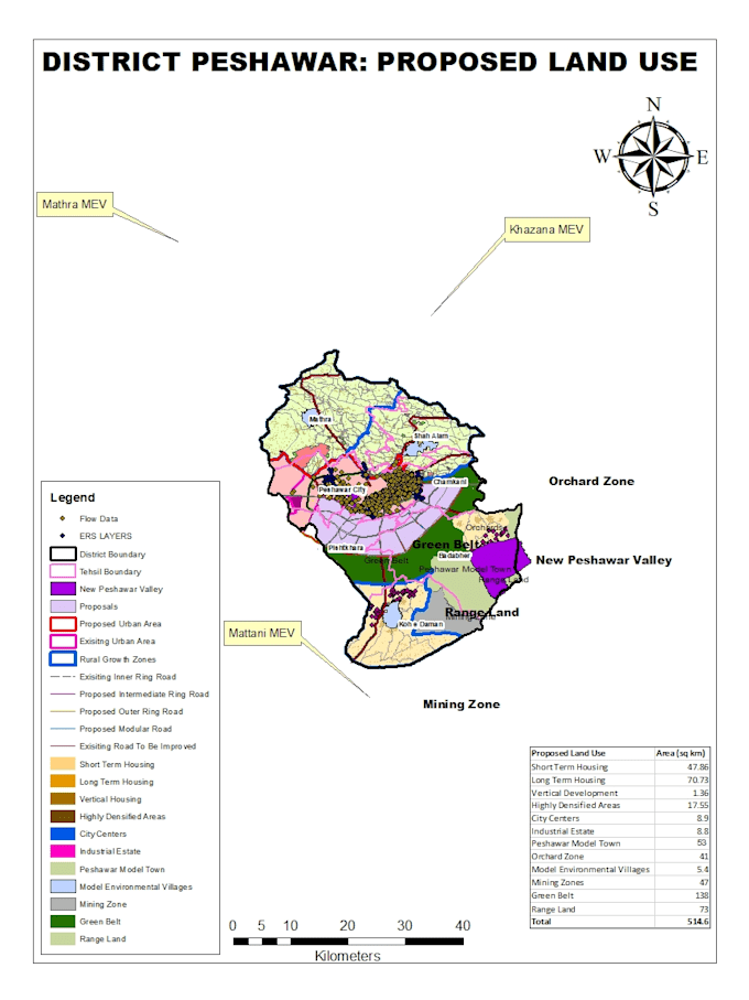
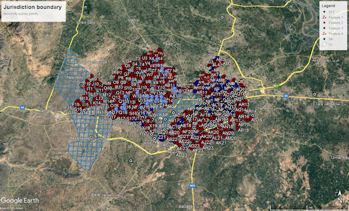
Working as a Research Associate and Field Engineer on the “Ground Water Modelling of Peshawar” project, contributing to hydrogeological investigations, subsurface exploration, and advanced groundwater modeling. Conducting Electrical Resistivity Surveys (VES/ERT) for aquifer characterization and subsurface profiling. Responsible for field data acquisition, processing, interpretation, and preparation of detailed Resistivity Investigation Reports, including geoelectrical sections, sounding curves, and hydrogeological interpretations. Developing and calibrating groundwater flow models using MODFLOW for simulation and analysis of aquifer behavior. Performing spatial analysis, thematic mapping, contour generation, and watershed delineation using GIS, QGIS, Google Earth Pro, and Google Earth Engine for large-scale geospatial data analysis and visualization. Managing field equipment, supervising survey teams, ensuring data accuracy, and maintaining project documentation. Preparing comprehensive technical reports, maps, and professional presentations for stakeholders and project authorities. Focused on delivering data-driven solutions for sustainable groundwater management through integrated field investigations and advanced geospatial and numerical modeling techniques.
Junior Engineer
REHMAN HABIB CONSULTANT LAHORE,PAKISTAN • Fulltime
Oct 2022 - Dec 2024 • 2 yrs 2 mos
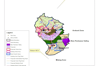
Project: “Increasing Storage Capacity & Improvement in Command Area of Tanda Dam, District Kohat” Performed site monitoring and inspection to ensure compliance with project specifications, drawings, and safety standards. Conducted regular condition surveys and supervised construction activities. Prepared daily, weekly, and monthly progress reports, meeting minutes, and site visit documentation. Assisted in reviewing interim payment certificates, variation orders, and escalation bills. Contributed to the preparation and digitization of the command area and sub-division land plans (Chak Bandi). Coordinated with contractors and stakeholders to maintain quality control and project schedules.
| (3) | ||
| (0) | ||
| (0) | ||
| (0) | ||
| (0) |
kate_riley42

Verenigde Staten
I sent in a dwg file and received a KMZ file that worked perfectly for us to use out in the field. Product was delivered on time and the process was easy. He checked my files first to make sure he could complete the conversion.
mksa9988

Marokko
Reactie van de freelancer

saimirkristozyx

Albanië
Outstanding Experience! Working with him was an absolute pleasure. He demonstrated exceptional attention to detail, clear communication, and a deep understanding of the project goals. The final result exceeded my expectations — delivered on time, perfectly executed, and with creative input that truly...
Reactie van de freelancer