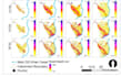
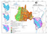
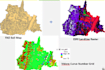
I will do gis spatial analysis, flood inundation mapping

H
hanansaif007
H
hanansaif007
Hanan Saif
Sommige informatie wordt in het Engels weergegeven.

Over deze dienst

I offer GIS-based spatial analysis services for hydrology, flood mapping and terrain Pre-processing. My work supports engineering projects through accurate spatial data processing and visualization.


Services Include:

  • DEM Processing and Terrain Correction
  • Watershed and Drainage Delineation
  • Floodplain Mapping
  • LandUse/Land Cover
  • Soil Raster
  • Mannings n Raster
  • CN Raster
  • Raster and Vector Analysis
  • Satellite Data Processing
  • Map Preparation for Reports and Presentations


Deliverables:

  • GIS Maps (Flood, Terrain, Catchment)
  • Shapefiles and Raster Data
  • High-quality Visual Outputs

Maak kennis met Hanan Saif

Hanan Saif

Hydrological Expert, Hydraulics and Drainage Engineer, Flood Specialist

5,0(2)
  • Afkomstig uitPakistan
  • Lid sindsaug 2020
  • Gem. reactietijd1 uur
  • Laatste levering2 jaar
  • Talen

    Engels
I am a Hydrologist and Hydraulic Engineer with professional experience in Flood Risk Assessment, Hydrodynamic Modelling, Climate Impact Assessment and GIS-based spatial analysis. I specialize in developing reliable, data-driven solutions for complex water and flood management problems. My approach is focused on technical accuracy, realistic modelling and clear interpretation of results for decision-making. If you need professional support in hydrological modelling, hydraulic simulation, or GIS-based flood analysis, I am here to deliver precise and dependable solutions.