Door categorieën bladeren
Ontdekken
Fiverr Pro
Nederlands
$
USD


Automatische vertaling
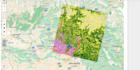
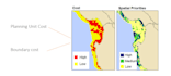
Ik ben een ervaren GIS-analist en ontwikkelaar met een diploma in Geo-Informatica. Met expertise in verschillende GIS-software zoals ArcGIS, QGIS en Erdas Imagine, ben ik gespecialiseerd in ruimtelijke analyse, GIS mapping en remote sensing. Als je op zoek bent naar gedetailleerde en nauwkeurige geospatiale analyse, ben je hier aan het juiste adres!
Wat ik voor jou kan doen:
GIS, GeoAI, Web Mapping, Remote Sensing Expert
Talen
Automatische vertaling
Automatische vertaling
Zijn de gegevens die ik met u deel veilig?
Ja, 100% veilig. Ik behandel alle data professioneel en zorg dat je privacy gerespecteerd wordt gedurende het hele project.
Bieden jullie ondersteuning nadat het project is afgerond?
Absoluut! Ik bied ondersteuning na het voltooien van de opdracht en kan persoonlijke hulp of revisies bieden indien nodig.
Welke software en tools gebruik je voor GIS-projecten?
Ik gebruik voornamelijk ArcGIS, QGIS en Erdas Imagine voor GIS-analyse. Voor web mapping gebruik ik tools zoals Google Maps API, Leaflet, MapBox en ArcGIS APIs.
Hoe lang duurt het om een GIS mapping of ruimtelijke analyse project te voltooien?
De levertijd hangt af van de complexiteit van het project. Kleine taken worden meestal binnen 2-3 dagen afgerond, terwijl complexere analyse- en mappingprojecten tot een week of langer kunnen duren. Stuur me gerust een bericht met je projectdetails voor een nauwkeurige planning.
Kan ik aangepaste verzoeken doen buiten de genoemde diensten?
Ja, ik sta open voor maatwerkprojecten! Als je diensten nodig hebt die niet in mijn gig staan, stuur me dan gerust een bericht met je wensen, dan bespreken we hoe ik kan helpen.
Wat moet ik aanleveren om aan de slag te gaan?
Geef gerust alle relevante data, zoals shapefiles, coördinaten, satellietbeelden of andere specifieke details over het project waar ik aan moet werken.
Kan ik revisies krijgen als het resultaat niet aan mijn wensen voldoet?
Ja, ik bied revisies totdat je volledig tevreden bent met het resultaat. Laat me weten welke aanpassingen nodig zijn, en ik zorg dat het geregeld wordt.
| (3) | ||
| (0) | ||
| (0) | ||
| (0) | ||
| (0) |

kaihenniges
Terugkerende klant

Zwitserland
You really helped to solve the issue I had.
Tot maximaal US$ 50
Prijs
10 dagen
Looptijd

explore009

Verenigde Staten
Very professional service
eusebiodstanley
Verenigde Staten
hayatullahabid was quick to communicate, quick to perform the spatial analysis I required, and completed a challenging project in a short amount of time. The word document he created for me with instructions was really helpful. Definitely recommended for the future.
| (3) | ||
| (0) | ||
| (0) | ||
| (0) | ||
| (0) |
kaihenniges
Terugkerende klant
Zwitserland
You really helped to solve the issue I had.
Tot maximaal US$ 50
Prijs
10 dagen
Looptijd
explore009
Verenigde Staten
Very professional service
eusebiodstanley
Verenigde Staten
hayatullahabid was quick to communicate, quick to perform the spatial analysis I required, and completed a challenging project in a short amount of time. The word document he created for me with instructions was really helpful. Definitely recommended for the future.


