Door categorieën bladeren
Nederlands
$
USD
Maak verbinding met je AI

Automatische vertaling
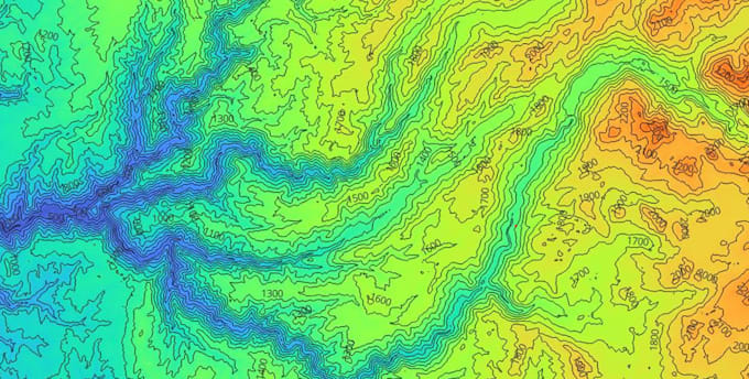
Wil je het terrein van je studiegebied begrijpen? Ik verwerk digitale hoogtemodellen (DEM) en zet ze om in duidelijke, kant-en-klare kaarten en data.
WAT JE KRIJGT
- Contourlijnen op het interval dat jij kiest, als shapefile
- Hellingshoek- en aspectkaarten met duidelijke classificatie en legenda
- Hillshade voor een realistische weergave van het reliëf (Premium)
- Eindlay-out met schaalbalk, noordpijl en legenda (Premium)
- Rasteroutputs in GeoTIFF, kaarten in hoge resolutie PNG/PDF
WAT IK VAN JOU NODIG HEB
- Jouw interessegebied (coördinaten, shapefile of regio naam)
- Jouw eigen DEM, of ik kan een openbare gebruiken (SRTM, Copernicus...)
- Contourinterval en hellingsklassen, als je voorkeuren hebt
IDEAAL VOOR
Geologische en geomorfologische studies, aardverschuivingen en hazard analyse, hydrologie, landgebruik, scripties en rapporten.
WAAROM IK
Ik ben een geowetenschapsstudent met praktische ervaring in terrainanalyse, veldgebaseerde geologische mapping en remote sensing. Ik werk met ArcGIS Pro en Python.
Weet je niet welk pakket je nodig hebt? Stuur me een bericht voordat je bestelt en ik help je kiezen.
GIS and Geospatial Analyst, QGIS and ArcGIS Pro
Talen
Automatische vertaling
Automatische vertaling
Kun je mijn eigen DEM gebruiken?
Ja, stuur het in GeoTIFF of een vergelijkbaar rasterformaat. Als je er geen hebt, kan ik een gratis openbare DEM gebruiken, zoals SRTM of Copernicus, en je eerst de resolutie vertellen.
Hoe gedetailleerd zullen de contourlijnen en hellingshoek zijn?
Dat hangt af van de resolutie van de DEM. Gratis wereldwijde DEMs hebben een resolutie van ongeveer 30 m, wat geschikt is voor regionale studies, niet voor gedetailleerde lokale analyses. Als je meer detail nodig hebt, stuur me dan een hogere resolutie DEM.
Welke formaten lever je?
Contourlijnen als shapefile, rasters als GeoTIFF, kaarten als PNG of PDF. Andere formaten op aanvraag.
Is er een limiet aan de grootte van het gebied?
Grote gebieden kosten meer tijd en kunnen het pakket overschrijden. Als je gebied groot is, stuur me dan een bericht voordat je bestelt en ik bevestig de prijs en timing.
| (1) | ||
| (0) | ||
| (0) | ||
| (0) | ||
| (0) |
arean8221

Duitsland
> Luca was very responsive, friendly and patient throughout the project. He sourced the official regional terrain data, added the protected trees to the model in the revision and tested a grid of positions, which gave me a solid basis for choosing the building location. The first version of the report...
US$ 100-US$ 200
Prijs
10 dagen
Looptijd
| (1) | ||
| (0) | ||
| (0) | ||
| (0) | ||
| (0) |
arean8221
Duitsland
> Luca was very responsive, friendly and patient throughout the project. He sourced the official regional terrain data, added the protected trees to the model in the revision and tested a grid of positions, which gave me a solid basis for choosing the building location. The first version of the report...
US$ 100-US$ 200
Prijs
10 dagen
Looptijd
