Ik verwerk dronebeelden met 3d-model, dsm dtm, orthomosaic door Agisoft, Pix4D

M
md_mulex
M
md_mulex
Md.alex
Sommige informatie is automatisch vertaald.

Over deze dienst

Automatische vertaling

Het leveren van alle beeldverwerkingsdiensten:

·      Dronebeeldverwerking met GCP

·      Dronebeeldverwerking zonder GCP

·      UAV drone mapping

·      Dichte point cloud bouwen

·      Lidar / Las point cloud verwerking

·      Tie points

·      Dichte point classificatie

·      3D model (OBJ, STL formats of andere)

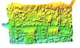
·      Build (DEM, DTM, DSM, TIN en orthomosaic)

·      Contourlijnen

Ik ben bedreven in deze software:

·      Agisoft Metashape Professional

·      Pix4D

·      ArcScene

·      Photoscan

·      ArcGIS

·      QGIS

·      AutoCAD

·      Civil 3D

Maak kennis met Md.alex

Md.alex

GIS and WebGIS Expert

4,9(9)
  • Afkomstig uitBangladesh
  • Lid sindsaug 2020
  • Gem. reactietijd1 uur
  • Laatste levering9 maanden
  • Talen

    Bengaals, Engels
I am Alekzandar, you can call Alex. I am a GIS and web GIS expert. I have completed a Bachelor's and Master's degree in geography and environment science. I have 8 years of experience at digital mapping center in Bangladesh. Not only computer base experience but also have field work experience in survey. I am proficient in GIS mapping and web GIS mapping. I've mostly work with Arc GIS, QGIS, postGIS, JavaScript, leaflet, Mapbox, Angular8, Open layer, python(folium, Pandas), PostgreSQL, MySQL, and Geoserver.I am always trying to work with punctuality, Sincerely and Honesty.

Automatische vertaling

Mijn portfolio