Ik doe GIS mapping, ruimtelijke analyse en geospatiale data visualisatie

M
micheal_map
M
micheal_map
Micheal Map
Sommige informatie is automatisch vertaald.

Over deze dienst

Automatische vertaling


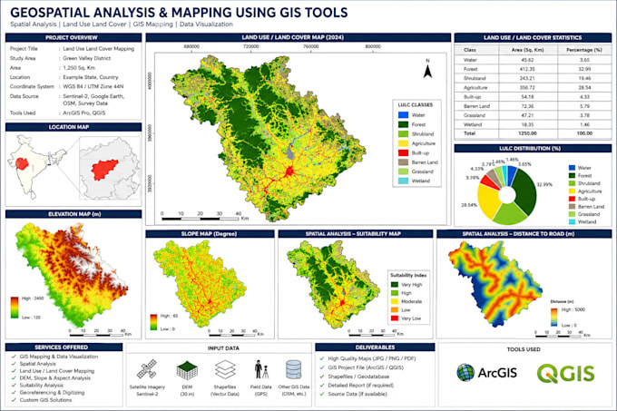
Ben je op zoek naar professionele geospatiale analyse en GIS mapping diensten? Je bent op de juiste plek. Ik ben gespecialiseerd in het maken van nauwkeurige, hoogwaardige geospatiale kaarten en ruimtelijke analyses voor landontwikkeling, milieustudies, stedelijke planning, vastgoed en onderzoeksprojecten met behulp van professionele GIS-tools zoals ArcGIS en QGIS.


Mijn diensten omvatten:

  • Geospatiale analyse
  • GIS mapping
  • Ruimtelijke data visualisatie
  • Landgebruik & landbedekkingsmapping
  • ArcGIS & QGIS projecten
  • Thematische & topografische kaarten
  • Georefereren & digitaliseren
  • Remote sensing analyse


Waarom voor mij kiezen:

  • Professioneel & nauwkeurig werk
  • Hoogwaardige kaartpresentatie
  • Snelle communicatie & levering
  • Aandacht voor detail
  • 100% tevredenheid van de klant


Ik zet me in om betrouwbare, gedetailleerde en professionele GIS-oplossingen te leveren die zijn afgestemd op jouw projectvereisten. Neem gerust contact met mij op voordat je je bestelling plaatst.

Maak kennis met Micheal Map

Micheal Map

GIS maps, ArcGIS analysis, and geospatial mapping solutions

  • Afkomstig uitVerenigde Staten
  • Lid sindsmei 2026
  • Talen

    Engels, Spaans, Duits
Hello and welcome to my profile I provide professional GIS mapping, geospatial analysis, and cartography services using ArcGIS, QGIS, MapInfo, and AutoCAD. I help clients create accurate maps, perform spatial analysis, develop interactive Web GIS solutions, and prepare site analysis for engineering, architecture, surveying, and planning projects. I am committed to clear communication, timely delivery, and client satisfaction. Whether you need a simple GIS map or a complete geospatial project, I am here to help.

Automatische vertaling