n
niazali24

Niaz Ali

@niazali24
5,0(1)

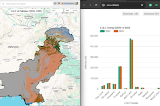
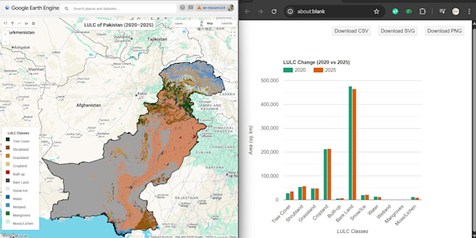
:::::::::(RS and GIS):::::::::: Sense : Analyze : Act

Pakistan
Engels, Urdu, Pasjtoe
Sommige informatie wordt in het Engels weergegeven.
Over mij
I am a Remote Sensing & GIS expert specializing in Google Earth Engine (GEE), ArcGIS, and QGIS. I collaborate with a professional architect to deliver complete geospatial and design solutions. My Services Include: GIS & Remote Sensing: ✅ GIS Mapping & Cartography ✅ LULC, NDVI/EVI Analysis ✅ Satellite Image Processing ✅ GEE & Climate Data Architecture (collaboration): ✅ 2D Plans & 3D Modeling ✅ Interior & Exterior Design ✔ Accurate, high-quality results ✔ Fast delivery & clear communication Message me to get started! ... Lees meer

Skills

n
niazali24
Niaz Ali
offline • 
Gemiddelde reactietijd: 1 uur

Bekijk mijn diensten

Geografisch informatiesysteem (GIS)
I will perform analysis using google earth engine, python , colab and r software
5,0(1)
Geografisch informatiesysteem (GIS)
I will analyze remote sensing , gis, geoai and environmental maps professionally

Portfolio

Werkervaring

Geospatial Analyst

The Spatio Geo-Spatial Engineering Consultants • Fulltime

Mar 2025 - Present1 yr 2 mos

Managing and executing geospatial projects for the Punjab Land Record Survey Enhancement (PULSE) project under the World Bank. Responsibilities include digitizing land records, updating Wanda data, creating public display maps, leading teams, social mobilization, and providing consultancy support to ensure accurate, sustainable, and community-engaged land management.

1 Reviews
5,0

(1)
(0)
(0)
(0)
(0)
Specificering van de beoordeling
  • Communicatieniveau van de freelancer
    5
  • Kwaliteit van de levering
    5
  • Waarde van de levering
    5
1-1 van 1 reviews
Sorteer op
Meest relevant
    A

    amalsaleh

    Terugkerende klant

    GB

    Verenigd Koninkrijk

    5

    Amazing professional. He Worked hard to get everything as we spoke. Delivered a perfect files that I can use away. highly recommended Thank you very much

    Tot maximaal US$ 50

    Prijs

    1 dag

    Looptijd

    gig

    Geografisch informatiesysteem (GIS)

    Nuttig?
    Ja
    Nee