I will do plat maps, parcel map, cadastral maps, boundary maps, easement maps, land map

O
oliverbendit
O
oliverbendit
Oliver Ben
Sommige informatie wordt in het Engels weergegeven.

Over deze dienst

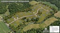
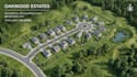
Every piece of land hides a story beneath lines, borders, and legal records I turn that complexity into clean, professional maps built for clarity, accuracy, and confidence. From property owners and surveyors to real estate developers and engineers, I create detailed mapping solutions that make land data easy to understand and ready for planning, legal use, and presentation. My work is designed to deliver precision with a polished visual style that stands out from ordinary mapping services.


What I Offer:


  • Plat Maps
  • Parcel Maps
  • Cadastral Maps
  • Boundary Maps
  • Easement Maps
  • Land Maps
  • GIS Mapping
  • Property Line Maps
  • Site Layout Maps
  • Custom Mapping Solutions


Why Choose Me:


  • Accurate & detail-focused work
  • Fast delivery with professional quality
  • Clean and visually organized maps
  • Reliable communication and support


Message me before placing your order so we can discuss your project and create the perfect map solution for your land needs.

Voorkeur voor een leveringsstijl

Laat het de freelancer weten als je voorkeuren voor of zorgen hebt over het gebruik van AI-tools voor het voltooien en/of leveren van je bestelling.

Maak kennis met Oliver Ben

Oliver Ben

Site plan

  • Afkomstig uitVerenigd Koninkrijk
  • Lid sindsmei 2026
  • Talen

    Engels
Hi, I’m Oliver, a subdivision mapping and land development specialist experienced in parcel maps, lot splits, grading plans, site layouts, and permit-ready drawings. I help developers, contractors, and property owners create accurate plans for residential, commercial, and mixed-use projects. My services include subdivision design, RV park and campground layouts, utility and drainage concepts, and city permit documentation using professional drafting and mapping standards.

Gerelateerde tags