Door categorieën bladeren
Ontdekken
Fiverr Pro
Nederlands
$
USD




Automatische vertaling
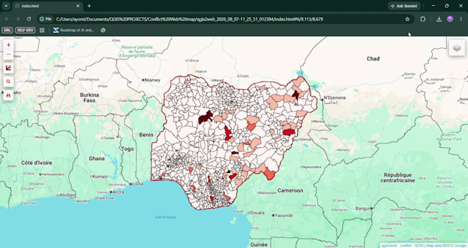
Ik bied professionele GIS mapping, ruimtelijke data-analyse en WebGIS-ontwikkeling op maat van jouw projectbehoeften. Of je nu aangepaste interactieve webkaarten, ruimtelijke data-visualisatie, routeoptimalisatie of complexe ruimtelijke analyse nodig hebt, ik lever nauwkeurige en hoogwaardige resultaten met behulp van industry-standard tools zoals QGIS, ArcGIS, Python en moderne web mapping bibliotheken.
Wat ik aanbied
Waarom kiezen voor deze service
Voel je vrij om me een bericht te sturen voordat je een bestelling plaatst, zodat we de scope van je project kunnen bespreken en de beste setup voor jouw behoeften kunnen kiezen.
GIS Specialist, GIS Developer, Spatial analyst
Talen
Automatische vertaling
Automatische vertaling
Welke details of data moet ik aanleveren voordat ik begin?
Lever je brongegevens aan (bijvoorbeeld Shapefiles, GeoJSON, CSV, Excel met coördinaten of ruimtelijke coördinaten), projectvereisten en eventuele specifieke voorkeuren voor kaartstijl, kleurenschema’s of lay-outformaten.
Welke GIS-software en tools gebruik je?
Ik werk met industry-standard tools zoals QGIS, ArcGIS Pro, Python (GeoPandas, Folium, Shapely), PostgreSQL/PostGIS en JavaScript-bibliotheken (Leaflet, Mapbox) voor WebGIS-projecten.
In welk formaat ontvang ik mijn eindbestanden?
De opleveringen hangen af van je projectbehoeften. Ze kunnen bestaan uit high-res kaartafbeeldingen (PDF, PNG, JPG), ruimtelijke vectorgegevens (Shapefile, GeoJSON, KML), standalone HTML-bestanden voor interactieve webkaarten of broncode voor aangepaste scripts.
Kun je interactieve webkaarten maken die ik op mijn website kan embedden?
Zeker. Ik ontwikkel interactieve WebGIS dashboards en kaarten die direct op je website kunnen worden ingebed of online worden gehost voor gebruikersinteractie.
Moet ik contact met u opnemen voordat ik een bestelling plaats?
Ja, stuur eerst een bericht. Het vooraf bespreken van je wensen zorgt ervoor dat we het juiste pakket kiezen, duidelijke verwachtingen stellen en onnodige vertragingen voorkomen.
Kun je werken met onvolledige of ruwe ruimtelijke data?
Ja. Ik kan ruwe adres- of coördinaatgegevens schoonmaken, formatteren, geocoderen en structureren zodat ze klaar zijn voor ruimtelijke analyse en mapping.