Ik maak professionele gis-kaarten voor geologie, geotechniek en hazard analyse

P
phubwangdi
P
phubwangdi
Phub Wangdi
Sommige informatie is automatisch vertaald.

Over deze dienst

Automatische vertaling

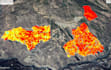
Ben je op zoek naar professionele GIS-mapping en ruimtelijke data-analyse?

Ik bied hoogwaardige GIS-data management, ruimtelijke analyse en professionele kaartcreatie voor geologische, milieuprojecten en hazard assessment.

Met uitgebreide ervaring in GIS-data verwerking en ruimtelijke analyse kan ik ruwe ruimtelijke data omzetten in heldere, nauwkeurige en visueel professionele kaarten die geschikt zijn voor rapporten, onderzoek en projectplanning.

Maak kennis met Phub Wangdi

Phub Wangdi

Engineering Geologist Data Analysist and

  • Afkomstig uitBhutan
  • Lid sindsokt 2024
  • Talen

    Engels
I am a geotechnical and geophysical professional experienced in investigation planning, data processing, interpretation, and technical report writing for engineering and infrastructure projects. My expertise includes geotechnical investigation planning, borehole log interpretation, and preparation of structured geotechnical reports. I also specialize in geophysical survey planning and interpretation using ERT, SRT, MASW, and GPR. In addition, I provide GIS mapping, hazard mapping, and support for mining investigation planning, delivering accurate analysis and clear professional reports.

Automatische vertaling