Door categorieën bladeren
Ontdekken
Fiverr Pro
Nederlands
$
USD

Automatische vertaling
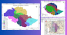
Als je op zoek bent naar GIS Mapping en Remote Sensing-taken, is dit de juiste dienst voor jou.
Ik ben een GIS Professional en Cartograaf met een bachelor in GIS & RS. Ik heb meer dan 3 jaar ervaring in GIS-toepassingen en ik hou ervan om echte wereldproblemen op te lossen of uit te leggen met GIS-kaarten en Data Visualisatie. Ik kan je ook helpen met je Onderzoeksproject.
Ik geef LEVEN aan je data!
Diensten :
Software die ik het meest gebruik :
Neem contact met me op voordat je bestellingen plaatst. Proost!
Gis and Drone operation Expert
Talen
Automatische vertaling
Automatische vertaling
Wat is GIS en welke voordelen kan het bieden voor mijn project?
GIS staat voor Geographic Information System, een technologie die wordt gebruikt om ruimtelijke data te analyseren, visualiseren, interpreteren en begrijpen. Het kan je project ten goede komen door waardevolle inzichten te bieden, te helpen bij besluitvorming en planning en resource-allocatie te verbeteren.
Welke soorten GIS-diensten bied je aan?
Ik bied een scala aan GIS-diensten aan, waaronder ruimtelijke analyse, kaartcreatie, data visualisatie, geocoding, remote sensing analyse en GIS-advies op maat van jouw projectbehoeften.
Welke software gebruik je voor GIS-projecten?
Ik ben bedreven in verschillende GIS-software zoals ArcGIS, QGIS en andere gespecialiseerde tools, afhankelijk van de eisen van jouw project.
Kun je werken met zowel raster- als vectorgegevens?
Ja, ik heb ervaring met zowel raster- als vectorgegevens, waardoor ik diverse ruimtelijke datatypes effectief kan verwerken.
Hoe ga je om met gevoelige of vertrouwelijke ruimtelijke data?
Ik geef prioriteit aan klantgeheimhouding en volg strikte databeveiligingsmaatregelen. Ik sta open voor het ondertekenen van Non-Disclosure Agreements (NDA's) om je gevoelige informatie te beschermen.


