Het lijkt erop dat deze dienst tijdelijk niet beschikbaar is

I will make and analyze interactive gis maps in python

Z
zeerakwyne
Z
zeerakwyne
Zeerak Wyne
Sommige informatie wordt in het Engels weergegeven.

Over deze dienst

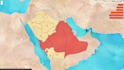
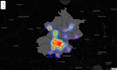
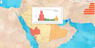
GIS systems are very important because they can be used to analyze information that would not be evident otherwise. I specialize in Designing a Interactive GIS system in python that can display a lot of information in once place.


Please have a look at project videos and images to see the work I have implemented.


Message before placing order so we can discuss the implementation

Maak kennis met Zeerak Wyne

Zeerak Wyne

Data Scientist and Machine Learning by passion and profession

4,9(33)
  • Afkomstig uitAustralië
  • Lid sindsjun 2016
  • Laatste levering1 jaar
  • Talen

    Engels
Hi, My name is Zeerak and I am a Data Scientist by profession and passion. I have expertise in Python and its various frameworks used in the development of Data Science, Machine Learning and Deep Learning pipelines. I have 5+ years of experience in building Deep Learning and Data Science applications that leverage data to generate useful output and predictions for the real world use and have managed to deploy them on cloud platforms like AWS. Skills - Time Series Forecasting, Deep Learning, Image Processing, Natural Language Processing, Scraping, Chatbot Development, AWS Lambda

Mijn portfolio

Gerelateerde tags