Door categorieën bladeren
Ontdekken
Fiverr Pro
Nederlands
$
USD


Automatische vertaling
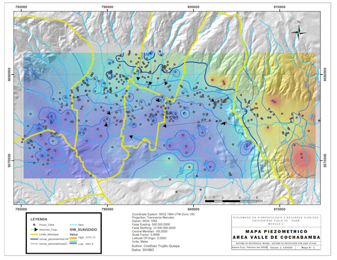
Ben je op zoek naar nauwkeurige, professionele geologische of thematische kaarten voor jouw project?
Ik ben een geoloog en GIS-specialist met meer dan 5 jaar ervaring bij SERGEOMIN (Bolivia's nationale geologische survey). Ik produceer kaarten van hoge kwaliteit en ruimtelijke analyses met ArcGIS, QGIS, ENVI en Google Earth Engine.
WAT JE KRIJGT:
WAAROM KIES JE VOOR MIJ:
Stuur me gewoon je data en interessegebied, ik regel de rest.
GIS Analyst and Geologist, ArcGIS ENVI Drone Photogrammetry
Talen
Automatische vertaling
Automatische vertaling
Welke data moet ik aanleveren?
Deel gewoon je interessegebied (coördinaten, shapefile of een kaart) en alle data die je hebt (hoogte, satellietbeelden, veldgegevens). Ik kan ook werken met openbare data als je geen eigen data hebt.
Welke bestandsformaten zal ik ontvangen?
Je ontvangt PNG en PDF bestanden die printklaar zijn. Shapefiles en GeoTIFF zijn inbegrepen in de Standard en Premium pakketten.
Kun je werken met mijn specifieke studiegebied?
Ja, ik werk met elke locatie wereldwijd. Ik heb ervaring met projecten in Bolivia, Peru en heel Latijns-Amerika, maar ik kan data verwerken uit elke regio.