Ik lever professionele photogrammetrie, mapping en 3d reconstructie diensten

G
ghulam_m015
G
ghulam_m015
Ghulam M
Sommige informatie is automatisch vertaald.

Over deze dienst

Automatische vertaling

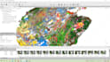
Transformeer je beelden in nauwkeurige geospatiale producten met professionele photogrammetriediensten. Ik verwerk drone-, lucht-, terrestrische en close-range beelden om hoogwaardige kaarten en 3D-reconstructies te maken voor landmeting, bouw, mijnbouw, landbouw, architectuur, archeologie, milieumonitoring en GIS-toepassingen.

Voorkeur voor een leveringsstijl

Laat het de freelancer weten als je voorkeuren voor of zorgen hebt over het gebruik van AI-tools voor het voltooien en/of leveren van je bestelling.

Maak kennis met Ghulam M

Ghulam M

Precision GIS,Remote Sensing and Photogrammetry Service

  • Afkomstig uitPakistan
  • Lid sindsaug 2025
  • Gem. reactietijd1 uur
  • Laatste levering1 maand
  • Talen

    Urdu, Engels, Russisch
I hold a Master Degree in Remote Sensing and GIS and work as a skilled GIS Analyst. I specialize in map design, spatial analysis, photogrammetry, and satellite image processing. I’m proficient in tools like ArcGIS, QGIS, ERDAS Imagine, Pix4D, Agisoft Metashape, and other photogrammetric software. I deliver accurate, high-quality geospatial solutions tailored to your needs — from land use mapping and 3D modeling to remote sensing analysis and visualizations.

Automatische vertaling

Mijn portfolio

Gerelateerde tags