Door categorieën bladeren
Ontdekken
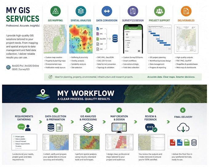
Fiverr Pro
Nederlands
$
USD

Senior GIS Data Analyst Australia
Skills
Bekijk mijn diensten
Senior GIS and Data Analyst
Government • Fulltime
Mar 2024 - Present • 2 yrs 4 mos
- Supported the administration, restructure, and optimisation of ArcGIS Enterprise environments - Delivered public-facing GIS web applications and maps to support transparency and community access - Designed and published web maps, dashboards, and apps using the ArcGIS Enterprise platform - Managed spatial data workflows including services, permissions, and data governance - Developed and documented GIS Standard Operating Procedures (SOPs) to improve consistency and best practice - Worked with internal stakeholders to modernise GIS systems and improve usability across teams
Senior GIS Analyst
KBR • Fulltime
Jan 2022 - Mar 2024 • 2 yrs 2 mos
- Delivered GIS mapping and spatial analysis for large-scale infrastructure projects across Australia - Provided spatial support to multi-disciplinary engineering and planning teams nationwide - Produced professional, publication-ready maps for technical reports and stakeholder engagement - Managed and analysed complex spatial datasets supporting national project delivery - Ensured GIS outputs met project standards, quality requirements, and timelines
GIS Analyst
RPM • Fulltime
Jan 2018 - Jan 2022 • 4 yrs
- Produced GIS maps and spatial analysis to support property, planning, and land development projects - Created property-related mapping including site context, constraints, overlays, and location analysis - Managed and maintained spatial datasets used for property assessment and reporting - Delivered clear, client-ready maps for property reports, proposals, and decision-making - Supported internal teams with spatial insights to assist property evaluation and planning outcomes
