Venkatesh

@venkatesh716
4,7(18)

Level 2

Drone GIS BIM 3D Expert

India
Tamil, Engels, Hindi, Kannada
Sommige informatie wordt in het Engels weergegeven.
Over mij
Welcome to my profile! With 10 years of experience in the drone surveying industry, I offer a wide range of services to help you unlock the full potential of your data. From processing and analyzing data with multiple software to delivering end-to-end drone outputs, I've got you covered. "As a UAV Expert, I'm providing: - Drone data processing with Pix4D, Agisoft and more. - GIS Analysis (Ortho, DSM, DTM, Contour, Topo, etc.) - Scan to BIM & Cad to BIM - 360 Virtual tours & Custom Skins Whether you need accurate 2D, 3D, BIM models, detailed GIS analysis, 360 Virtual tours . I'm here to help.... Lees meer

Skills

v
venkatesh716
Venkatesh
offline • 
Gemiddelde reactietijd: 1 uur

Bekijk mijn diensten

Geografisch informatiesysteem (GIS)
I will do uav drone photogrammetry and deliver dsm dtm contour 3d point cloud
4,4(7)
Geografisch informatiesysteem (GIS)
I will process uav drone data and create orthomosaic 3d models point cloud dsm gis
5,0(5)

Portfolio

Werkervaring

GIS Analyst & Drone Pilot

Cape Geospatial • Fulltime

Dec 2018 - May 20201 yr 5 mos

UAV operations | Image Processing | GIS Analysis

Drone Pilot

RSI Softech India Pvt Ltd • Fulltime

Jul 2018 - Dec 20185 mos

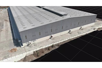
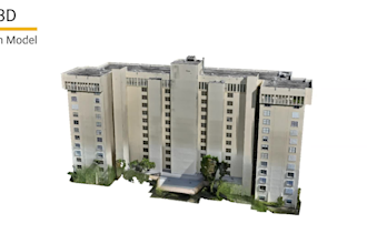
Drone data aquisition, Image processing, Georeferencing, 3D city modeling Project(Chennai city)

18 Reviews
4,7

(15)
(2)
(0)
(0)
(1)
Specificering van de beoordeling
  • Communicatieniveau van de freelancer
    4,7
  • Kwaliteit van de levering
    4,7
  • Waarde van de levering
    4,7
1-5 van 18 reviews
Sorteer op
Meest relevant
    D
    image-docs

    dominickschille

    US

    Verenigde Staten

    5

    Perfect thank you, very professional and accurate.

    US$ 50-US$ 100

    Prijs

    1 dag

    Looptijd

    gig

    Geografisch informatiesysteem (GIS)

    Werkvoorbeeld
    Nuttig?
    Ja
    Nee
    G
    image-docs

    godejnan

    SI

    Slovenië

    5

    Satisfied with the work and responsiveness.

    Tot maximaal US$ 50

    Prijs

    2 dagen

    Looptijd

    gig

    Vastgoedfotografen

    Nuttig?
    Ja
    Nee
    C

    clarkgibson

    Terugkerende klant

    GB

    Verenigd Koninkrijk

    5

    Extremely professional and very responsive. Great level of understanding of what is required converting our drone footage into a topo survey. We will continue to work with them on our future projects. Thank you

    US$ 200-US$ 400

    Prijs

    7 dagen

    Looptijd

    gig

    Geografisch informatiesysteem (GIS)

    Nuttig?
    Ja
    Nee
    A

    almass_

    SA

    Saoedi-Arabië

    5

    He did a great job on my Pano2VR. The scenes were smooth, the animations matched exactly what I asked for, and he was fast with every update. The final result looked polished, creative, and better than I expected. Definitely recommend!

    US$ 100-US$ 200

    Prijs

    5 dagen

    Looptijd

    gig

    Vastgoedfotografen

    Nuttig?
    Ja
    Nee
    A

    alastair_petch

    MY

    Maleisië

    5

    Good, quality outputs, quick communication 👌

    US$ 200-US$ 400

    Prijs

    5 dagen

    Looptijd

    gig

    Geografisch informatiesysteem (GIS)

    Nuttig?
    Ja
    Nee